Add TOPKHOJ on Google:
 Preferred Source
For years, iPhone users in India have treated Google Maps as a mandatory first download, as Apple’s native mapping service lacked detailed road geometry, street-level imagery, and localized routing cues. Despite Apple operating a dedicated Maps development center in Hyderabad since 2016 and enabling turn-by-turn navigation in 2019, the company’s ground-up map redesign had remained absent from the country.
That gap officially closed on November 18, 2026, with the nationwide rollout of the redesigned Apple Maps experience across India.
Highlighting the tailored engineering behind the release, Max Muller, Apple’s Vice President of Apple Maps, noted that beyond bringing global favorites like Look Around and AR Walking Directions to Indian users, the team designed the platform for India’s specific navigation needs-including enhanced Natural Language Guidance and customized dual-language labels.
India-First Navigation: Natural Language Guidance & Dual-Language Labels
Navigating Indian cities often relies far more on visual anchors than formal street signs-especially where local lanes are unnamed. Apple built two core localized tools directly into the updated map to mirror real-world Indian commuting:
- Enhanced Natural Language Guidance: Instead of generic distance-only prompts, spoken directions now reference familiar local landmarks such as traffic signals, petrol pumps, and flyover pillars to make turns clearer in dense traffic.
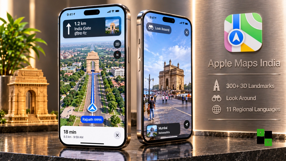
- Dual-Language Labels (11 Regional Languages): Mirroring bilingual physical signboards across the country, Apple Maps displays place names in both English and the local regional language based on device settings and location-such as Hindi and English in Delhi, or Marathi and English in Mumbai. Supported Indian languages include Hindi, Bengali, Gujarati, Kannada, Malayalam, Marathi, Tamil, Telugu, Punjabi, Odia, and Urdu.
- Software Requirement: Apple notes that both dual-language labels and the enhanced Natural Language Guidance require iOS 27.2, iPadOS 27.2, watchOS 27.2, or macOS 27.2 or later.
Look Around, 300+ 3D Landmarks & AR Walking Directions
The visual presentation of Indian cities receives a dramatic upgrade, moving from sparse flat vectors to rich spatial detail:
- 300+ Custom 3D Landmarks: Major monuments and civic structures-including the Qutb Complex in New Delhi, the Brihanmumbai Municipal Corporation Building in Mumbai, and Ekana Cricket Stadium-now render with detailed three-dimensional geometry alongside improved road networks and building footprints.
- Look Around Street Imagery: Debuting in India for the first time, Look Around delivers interactive, high-resolution 3D street-level photography with fluid transitions so users can inspect destinations before arriving.
- AR Walking Directions: Pedestrians can raise their iPhone to scan nearby buildings and see step-by-step walking arrows overlaid directly onto the real-world streetscape through the camera.
Driving, EV Routing, Cycling & Eight-City Transit Planning
Beyond visual polish, Apple Maps adds a comprehensive suite of multi-modal commuting tools tailored to daily drivers, riders, and rail passengers:
- Lane Guidance & Multi-Stop Routing: Lane guidance helps drivers position themselves early before complex turns or elevated roads and flyovers. Users can plan multi-stop trips with up to 15 stops, and routes created on a Mac or iPad sync automatically to an iPhone.
- Speed Limits, Incident Reports & Share ETA: Drivers gain speed limit indicators, hands-free reporting for accidents, hazards, and speed checks via Siri, and one-tap Share ETA that automatically alerts contacts if traffic causes a significant delay.
- EV Charging & Cycling Directions: Electric vehicle owners get EV charging information and routing that accounts for elevation and road conditions. Cyclists receive dedicated routes highlighting elevation changes, bike lanes, and stair callouts.
- Custom & Preferred Routes: Users can draw and save custom paths along roads or trails, while Preferred Routes uses on-device intelligence to learn regular commutes (such as home-to-work) and surface traffic previews before departure.
- Public Transit & Indian Railways: Real-time transit planning, station lookup, pinned routes, and drop-off stop notifications are now live across eight major cities-Ahmedabad, Bengaluru, Chennai, Delhi, Hyderabad, Kolkata, Mumbai, and Pune-as well as Indian Railways.
Platform Comparison: Redesigned Apple Maps India vs. Google Maps India
| Navigation Dimension | Apple Maps India (Nov 2026) | Google Maps India |
| Street-Level Imagery | Look Around (High-Res 3D) | Street View |
| AR Pedestrian Navigation | AR Walking Directions | Live View AR |
| Landmark Voice Cues | Natural Language Guidance (Signals/Petrol Pumps) | Landmark & Flyover Callouts |
| Regional Language Labels | Dual-Language (English + 11 Indian Languages) | Regional Language Support |
| 3D City Landmarks | 300+ Detailed 3D Landmarks | 3D Buildings & Immersive View |
| Multi-Stop Trip Planning | Up to 15 Stops (Mac/iPad Sync) | Up to 10 Stops |
| Public Transit Coverage | 8 Major Cities + Indian Railways | Broad Pan-India Transit & Metro |
| Privacy Architecture | No Sign-In, On-Device AI, 24-Hr Location Fuzzing | Account-Linked History (Optional Incognito) |
Privacy Architecture & Market Verdict
Apple is positioning privacy as its sharpest differentiator against Google Maps in India. Apple Maps requires no user sign-in, computes personalized commute suggestions entirely on-device, ties navigation and traffic data to regularly reset random identifiers, and uses location fuzzing to convert precise search origins into less-exact areas on Apple servers within 24 hours.
Final Verdict:
- A Genuine Alternative for iPhone Users: With 300+ 3D landmarks, Look Around, lane guidance for elevated roads, and 11-language dual labels, Apple Maps finally feels built for India rather than ported as an afterthought.
- Real-World Local Polish: Referencing petrol pumps and flyover pillars in spoken guidance directly addresses how Indian commuters actually give and follow directions.
- Ecosystem Advantage: Deep integration with Indian Railways, CarPlay, Mac-to-iPhone route syncing, and Apple’s strict no-sign-in privacy model gives Apple users a compelling reason to revisit the native app-though Google Maps still holds a massive lead in hyper-local business reviews and two-wheeler routing.
🚨 Stay Updated with TopKhoj! 🚨
Get the latest tech news, deals, and exclusive offers first!
📰 Visit News Section📲 Join our Telegram Channel for real-time updates and best deals!
🔗 Join Telegram Now💡 Stay informed and never miss a great deal with TopKhoj!
⚠️ Disclaimer: Any link provided in the article related to a product or service will redirect you to our affiliate partner(s)' website, which are affiliate links. This means that if you make a purchase through these links, we may earn a commission at no extra cost to you. This commission helps support our blog and our work.
🔔 All prices mentioned above are subject to change based on current offers and availability on e-commerce platforms. Please check the latest price and product details on the product page before making a purchase.